Geostationary satellite images - 3:

GMS 5 - The Far East and Australasia
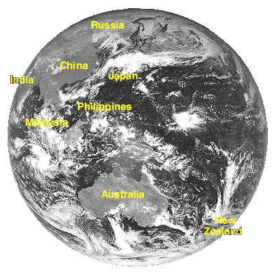
GMS provides coverage of the 'Taifun' (Typhoon) zone - the Indian and Pacific Ocean variants of the Atlantic hurricane.
GMS images
Images distributed in Europe
Two infra red WEFAX segments from the GMS whole disk image are retransmitted via the European Meteosat system. These images do not show the whole view from GMS - but do show the areas of most interest - the Asian mainland and offshore islands and Australasia (Australia, New Zealand, Papua New Guinea, Oceania).


Asian mainland and offshore islands
Australasia and Oceania
Dundee High Resolution Images - http://www.sat.dundee.ac.uk/pdus.html
Scroll down page to locate GMS data
GMS - Asia and Australasia images and Weather information
Images from the GMS platform are available from a number of sites and in a variety of formats. Many of the sites in the list below will provide links to other sites with more information.
- Japan Meteorological Agency - English page
- Hong Kong Observatory - English language page
- Hong Kong Observatory: Weather charts
- Hong Kong Observatory: Weather satellite images
- Bureau of Meteorology, Australia
- Satellite Images: Australian Bureau of Meteorology
- NASA Goddard Remote Sensing Data - GMS 5 images
- US Navy Pacific Met. Center - Indian Ocean - Typhoon warning center
- US Navy Pacific Met. Center - Western Pacific Ocean - Typhoon warning center

Page update: January 1999
This version: © St Vincent College