Geostationary satellite images - 2:

Geostationary Operational Environmental Satellites - GOES

GOES platform NOAA logo

The Americas - GOES East and GOES West

The GOES satellites are operated by the US National Oceanographic and Atmospheric Administration (NOAA) to provide geostationary weather observations covering the whole of the Americas - both North and South. To provide full coverage across the American landmasses and the surrounding oceans, two satellites are in use - GOES East, orbiting at 75°W and GOES West orbiting at 135°W.

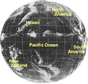
From their orbital position, the 2 satellites cover nearly half the surface area of the globe - from New Zealand in the far west, across the Pacific Ocean, North and South America and the Atlantic Ocean to the western coast of Africa.

The GOES satellites are unable to 'see' Europe, Africa, the Indian Ocean, India and Asia.

full disk - GOES W full disk - GOES E
GOES W - 135°W GOES E - 75°W
Images from the US satellites are extremely important in forecasting global weather. European weather systems often start in the warm waters of the Western Atlantic and then track north east towards Europe. Images from the GOES E satellite can show the origins of these systems and give early warnings of changes in European systems - particularly important for the North West coast of Europe (UK, France, Spain etc) where Atlantic depressions bring rain and stormy conditions.

Once weather systems move away from the Western Atlantic and Caribbean regions they are detected by Meteosat, the European satellite orbiting at 0°, providing a continuous observation from formation to decay.

GOES W observes the Pacific Ocean, providing valuable data on systems moving towards the Western USA and South America - and also in a ideal position to observe the changes brought about by El Niño and La Niña.

GOES images

Images collected in Europe

A regular series of image segments from GOES E are collected at CMS Lannion in Brittany on the far western coast of France and redistributed via Metosat. These images provide cover of the areas of most interest to European forecasts - and also give good coverage of the 'Hurricane Alley' zone of the Caribbean and Central America. Images are transmitted throughout the day.

GOES E image: LR GOES E: LR segment
Thermal Infra Red - South America
GOES E image: LY GOES E: LY segment
Thermal Infra Red - Central and North America
GOES E image: LZ GOES E: LZ segment
Visible band - Caribbean and Eastern USA
Full disk GOES images - via Meteosat HRI

Full disk images from GOES East and GOES West are available via the Meteosat High Resolution server at Dundee University. Full disk images are large (500k) and are available in Visible and Thermal Infra Red bands.

Hurricane season!


Hurricane Mitch - Category 5 hurricane - 26th October 1998 - Image: NOAA

During the Hurricane Season - normally from August to October - image formats LY and LZ provide good coverage of hurricane formation in the warm waters of the western Atlantic and then the subsequent storm track through the Caribbean to Jamaica and Cuba and then on to mainland USA (Florida) and the Gulf of Mexico.

GOES satellite imagery web pages

GOES: continental USA

There are a wide range of sites providing access to current and archive images from the GOES platforms. A selection are listed here - others can be found by following links within these pages:


Back icon Return to images front page

Page update: January 1999
This version: © St. Vincent College