Here is the weather for sea area ....... |
|||||||||||||||||||||||||||||||||||||||||||||||||||||||||
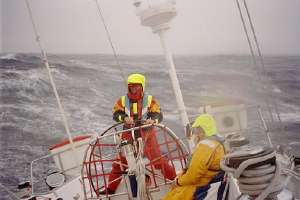 |
Courtaulds sailing in rough seas - BT Global Challenge | ||||||||||||||||||||||||||||||||||||||||||||||||||||||||
Marine forecast informationWeather forecasts are extremely important for both sailors and airmen with the latest information of crucial importance for both comfort and safety. Operators can route ships and aircraft to avoid severe weather, reducing the risk of injury and damage (a number of passengers aboard an Air France Boeing 747 were injured when it was 'bounced' around in a thunderstorm - ferry passengers had to spend Christmas on board a cross-Channel ferry when it could not dock due to bad weather). Information is broadcast at regular intervals and provides details of current conditions and expected weather for the next few hours. This information can be obtained fairly easily and added to observations that you can make in your own school and local region. |

|
||||||||||||||||||||||||||||||||||||||||||||||||||||||||
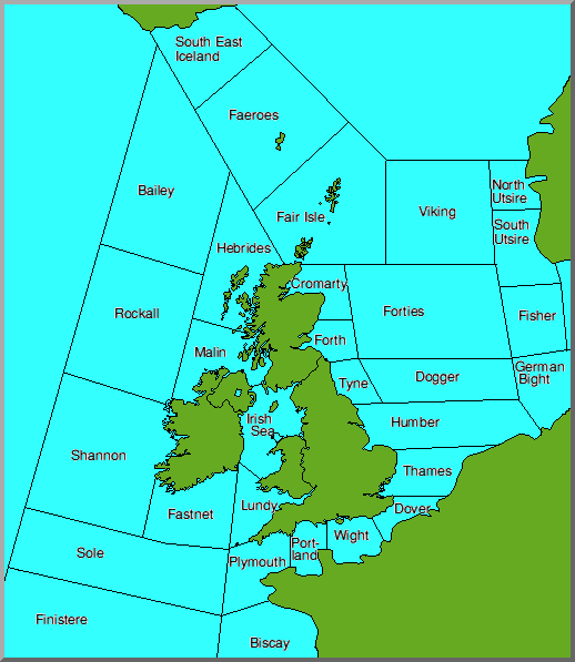
The Shipping ForecastShipping forecasts are broadcast each day on BBC Radio 4 FM (92.4 - 94.6 MHz) at 05.55, 13.55, 17.50 and 00.48 hours. Each bulletin contains 350 words and begins with warnings of gales (when issued) followed by a general summary of current weather conditions: Gale Warnings There are warnings of gales in sea areas Plymouth, Sole, Lundy, Fastnet, Finisterre and Biscay......
Plymouth; South Westerly 8, occasionally 9 imminent Sole, Finisterre; West 8, decreasing 7 soon Low Southern Irish Sea 978 moving rapidly expected Forth 985 by 1900 Saturday. High Azores 1030 slow moving with little change and then moves on to give forecasts for the various sea areas around the UK. The area forecasts for the next 24 hours
Dover, Wight, Portland The forecast for sea areas around the UK is followed by reports from coastal weather stations - a series of reports in a clockwise order around the UK. The current marine forecast can be downloaded from the Met. Office internet site:
|
|||||||||||||||||||||||||||||||||||||||||||||||||||||||||
|
|
|||||||||||||||||||||||||||||||||||||||||||||||||||||||||
Shipping speakThe shipping forecast contains a number of unusual terms, used to convey specific meanings....... Gales
And now for the reports from coastal stations......The weather forecast is followed by coastal reports, again in clockwise order round the UK. Reports give current pressure and trend (rising, falling, steady), wind direction and force, current weather (rain, showers etc.)and visibility. Today, much of the data is acquired from automatic weather stations mounted on floating buoys in strategic locations. The data from these buoys can be downloaded directly to give an immediate (usually within the last hour) feel for weather conditions. |
|||||||||||||||||||||||||||||||||||||||||||||||||||||||||
 |
Automatic weather observation buoy data can be accessed via the Internet from the Ocean Weather Inc. Marine Observations: North Sea |
| Click on a buoy from this site to display current conditions (including wind, temperature, pressure, wave height and wave period). Data for previous hours is also displayed and can be used to observe the progress of weather systems. | |
| Interactive Marine Observations are available for 14 regions of the Northern Hemisphere. Click the link to choose an area. | |
|
Plotted observations from ships and aircraft for wider areas are available from
OceanWeather Inc.
|
|
|
|
|
|
Information for Airmen
Accurate and up to date weather information is vital to the safety of aircraft. Current conditions at major UK airports is broadcast
continuously in the Air band. A tape recorded announcement (updated at half hourly intervals) is broadcast and can be heard
by tuning an air band radio to London Volmet Main at 135MHz. Information is provided for Amsterdam, Birmingham, Glasgow, London (Heathrow,
Gatwick and Stansted) Manchester, Paris Charles de Gaulle.
Important information on this broadcast includes wind speed and direction, cloud cover and ground visibility. |
|
|
Page update: January 12th 1999 |
|
