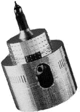
Meteosat
Imaging the Earth

- 0.4 - 1.1 µm - Visible light
5.7 - 7.1 µm - Infra Red - water vapour absorption
10.5 - 12.5 µm - Thermal infra red
The three wave bands are chosem to provide information of particular significance to weather forecasters. The main task of the radiometer system is to map the distribution of clouds and water vapour in the atmospheric region that it can 'see'. This is achieved by sensors that measure the amount of radiation coming from the earth in each of the three bands.
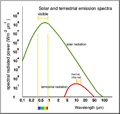 Solar and terrestrial emission spectrum
During daylight hours, the Earth reflects incoming visible light from the sun. The peak of solar radiation occurs within the visible band (which is why our eyes have evolved to make use of this high level of energy!). The atmosphere is fairly transparent to radiation in this band so there is little effect on both incoming and reflected solar radiation. As a result, Meteosat is able to detect strong signals. Generally, clouds reflect more sunshine than land or sea surfaces. The amount of reflected depends on the surface. Some surfaces, such as snow and clouds reflect well (and appear white) whilst others (such as the sea) absorb most of the incoming solar illumination and appear dark or even black to the satellite sensors. The amount of reflectance, as a percentage of incoming illumination, is known as the albedo.
In general terms, the deeper a cloud is, the more radiation it will reflect back out to space. This means that clouds stand out well from nearby cloud free surfaces. The satellite images are processed to enhance the contrast, making the clouds stand out well from the darker sea and land. Visible light images are of little use at night. During the northern winter, there is only a low level of visible illumination in the northern latitudes including the British Isles. These areas appear almost black in the visible band images.
The thermal infra red waveband lies in the 10.5 - 12.5 µm region. Like the visible radiation peak, this region of the radiometer sensitivity lies in the peak of the Earth and atmospheric irradiance. The amount of the thermal radiation emitted from the Earth depends on the surface temperature of the radiating body. Very hot bodies (such as the surface of the Sahara Desert in daytime) emit strongly whilst cold objects (such as snow or the tops of clouds) emit weakly. On a day in midsummer, the differences in temperature may be between 60 C in the Sahara and -70 C at the tops of clouds - a range far greater than that between the equator and the cold polar regions. A powerful signal with a shorter thermal wavelength means a hot source - which appears black on the infra red image. Colder surfaces (mainly clouds) appear grey or white.
Because the Earth is always warmer than the surrounding space, thermal infra red images can be captured at night as the earth continues to emit thermal band energy.
The water vapour absorption channel takes advantage of the fact that water vapour in the atmosphere strongly absorbs infra red energu in the 6µm band. If water is present in the atmosphere, the infra red energy radiated by the Earh will be strongly absorbed, leaving only a weak signal to reach the satellite. If the air is dry, little absorption occurs and a strong signal reaches the satellite. The image is processed to show dry areas as black and a moist atmosphere as white. Most of the absorption occurs in the upper atmosphere so there is often little agreement between the water vapour image and the presence of cloud as shown in visible and thermal infra red images.
Scanning the Earth
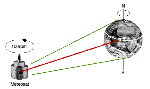
Meteosat is stabilised in its orbit by spinning it at 100 rpm about its long axis which is set parallel to the north/south axis of the Earth. This spin stabilisation provides the basic operation of the image scanner. This starts as the radiometer 'looks' at the region nearest the southern pole and completes its east/west scanline
Most of the time Meteosat's radiometer looks out into space. As the satellite rotates through 360°, the Earth only occupies 18° of its rotational view. Meteosat only 'sees' the earth for 18/360 ths of each revolution - about 30 milliseconds out of each 0.6 second rotation.
After each scanline in the sequence, the radiometer is tilted slightly northwards so that the next rotation scans the line that lies immediately to the north and just touching the previous scanline. Each line of digitally scanned data is transmitted in real time to the primary ground station where the line by line observations are built up to form a full image. Two infra red lines (one thermal, one water vapour) and two visible lines are transmitted for each rotation of the satellite. The observations are transmitted during the 570 ms of each revolution that the satellite is not looking at the Earth.
Each new image cycle starts at 00 and 30 minutes past each hour and takes 25 minutes to complete. The original image pictures are formed of 2500 east/west scanlines for the two infra red channels and 5000 lines in the visible band. As the satellite scans along each line, it takes one sample and creates a digitised value for each 5 km section in the infra red bands for each 2.5 km section in the visible band. This results in pixels having a ground resolution of 5 km in the infra red bands and 2.5 km in the visibl bands at the surface immediately below the satellite (the sub-satellite point). The curvature of the Earth means that the pixel resolution gets bigger away from the sub-satellite point.
Once the 25 minute scan is complete, the radiometer telescope is reset to start the whole cycle again. At the Darmstadt control center, the interleaved infra red and visible images are separated out and split into segments. The segmented images are geographically corrected, coastlines and lat/long grids are added then the secondary data images are uploaded to the satellite for distribution as WEFAX signals to secondary data user stations.

![]() Return to Meteosat information
Return to Meteosat information
Page updated: January 12th 1999
This version: © St. Vincent College