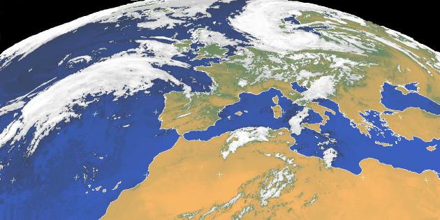
False colour high resolution image: Europe - June 1998
Meteosat High Resolution Images - HRI
The Meteosat orbiter generates high resolution images of the earth below it at 30 minute intervals. These images are transmitted as Primary Data User Station (PDUS) signals and show significantly higher resolutions than the secondary WEFAX images. Primary data signals are digital transmissions with a lower signal level than the WEFAX signals and require a larger dish antenna and different processing systems. Primary data signals are also normally encrypted - with only a few images each day being transmitted 'in clear'.
High resolution images are large and show the whole disk area below the satellite! Digital high resolution images in the Infra Red bands have a maximum resolution of 2500 x 2500 pixels and Visible band images have a resolution of 5000 x 5000 pixels (compared with the 800 x 800 of the secondary image formats). The satellite transmits the data to ground at a rate of 166 Kbit/second - taking about 25 minutes to transmit each complete disk image.
Secondary images are created by processing the primary data, splitting the image into the various segments (C1, C2, C3 etc) and adding coastlines and lat/long grids. Secondary signals are transmitted back to the satellite for distribution according to the published schedule. Secondary, WEFAX, transmissions are unencrypted analogue transmissions and are the type normally received in schools with 1m dishes and receivers interfaced to standard PCs.
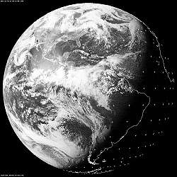 |
GOES-E images showing the Americas, North and South, from its orbital position at 75°W.
The image was taken in afternoon, local time, and shows the shadow of the approaching night creeping across the disk from the east. Note the angle of the approaching shadow to the equator - indicating the 23.5° tilt of the Earth in its orbit. |
| For more information about the GOES and NOAA satellites, visit the NOAA Satellite Operations home page |
Experimental service of PDUS images

The Dundee Satellite project is currently experimenting with PDUS imagery on the web. A range of images from around the world are available in various formats. Some images are restricted to 3 or 6 hourly updates due to encryption licensing. The site provides web access to European images (very high resolution) together with whole Earth disk images from Meteosat, GOES E, GOES W and GMS. An image archive is available.
Images can be downloaded in low, medium or high resolutions, with or without grid overlay. Full disk images in full resolution are large files and can be nearly 1Mbyte in length - with long download times for modem based users!
Please note that the Dundee service is experimental and that image availability may change without warning. The service is currently available without charge or registration.
Click the link to go to the Dundee project page - and a choice of image and format.
Dundee Geostationary archives: http://www.sat.dundee.ac.uk/pdus.html
The experimental geostationary service is part of the Dundee Satellite Receiving Station
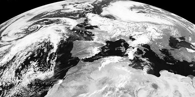
Primary data image: Europe - June 1998 - Dundee Satellite Receiving Station

Page update: January 12th 1999
This version: © St. Vincent College