Weather in the NEWS
January 1999 |

|
Storms lashed both Northern and Southern hemispheres as 1998 came to an end |
Boxing Day storm claims 5 lives in UKAfter the Christmas festivities came the storm - a deep depression raced in from the Atlantic to deliver winds of up to 100 mph across Northern Ireland and Scotland on Boxing Day (26th December). |
|

|
In the aftermath of the storm it became
clear that 5 people had lost their lives - including a man washed away from Brighton beach by a huge wave and a man
lost to flood waters in South Devon.
Across Scotland and Northern Ireland, 60,000 people were without electricity and the rooves were torn off a number of houses and blocks of flats. In Glasgow, the spire of a church crashed down through the main building and a number of cars were crushed when part of a hospital wall collapsed. In the North Sea, 2 RAF helicopters lifted 34 oil workers from the Ramforth Banff platform 90 miles east of Aberdeen after it was damaged in the violent storm force winds (Force 11 - only one step down from Hurricane force). |

26th December: 0600 hours |

26th December: 1800 hours |
|
The two charts show the movement of the storm during 26th December. The left hand chart shows the situation at 06:00 (6 o'clock in the
morning) with the centre of the depression well to the west of Ireland and with a central low pressure of 959 hPa. 12 hours later, at 18:00
(6 o'clock in the evening) the centre of the depression has moved east by some 500 miles (and has almost reached the Western Isles of Scotland)
and the central low has deepened to 946 hPa (an intensely low pressure). The tightly spaced isobars (isobars - lines joining places with
the same pressure) indicate the high wind speeds - the closer the isobars then the stronger the winds. Heavy rain fell as the frontal
systems moved across the British Isles - with severe flooding in South West England and Wales.
The chart for 18:00 showed that the frontal systems were now merging to form an occluded front (where the warmer air is lifted above the cold air). This suggested the onset of the mature stage of the depression - the central low would now fill and the wind strength would begin to fall. The UK Met. Office issued a further warning to shipping at 00:15 on 27th December:
THE GENERAL SYNOPSIS AT 1800
THE AREA FORECASTS FOR THE NEXT 24 HOURS
FORTIES CROMARTY
FORTH TYNE DOGGER FISHER GERMAN BIGHT HUMBER
The shipping report showed that the forecasters were now expecting the depression to fill as it moved across the North Sea. However, the pressure reading of 946 hPa was intensely low and there were still expectations of high winds for a few hours to come. The 18:00 chart shows the tight packed isobars and the front over the Forties region of the North Sea - the forecast for this area was for violent storm force winds (Force 11) - which resulted in damage to North Sea oil rigs. This was a huge atmospheric disturbance - as can be clearly seen in the Meteosat image of Europe taken in visible light at 12:00 (mid-day) on 26th December. The tight central 'eye' and swirling clouds of the depression are easily visible - but look at the extent and length of the huge mass of frontal clouds sweeping aross most of north west Europe and the Bay of Biscay and back into the Atlantic. |
|
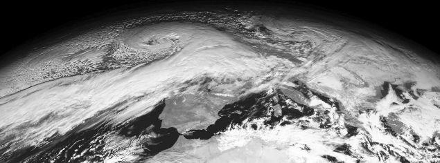
Meteosat visible band image: 12:00 26th December 1998 |
|
|
False colour image:
The NOAA image (above) is a false colour composite that has been created by merging three separate black and white images. The NOAA spacecraft takes a series of images as it passes overhead - in the visible and thermal infra-red bands. Each band is received as a black and white image with varying levels of grey. To make the colour composite, three image bands were collected - in visible light, near infra-red (just at the red end of the visible spectrum) and infra-red. The visible light band is shown in blue light, the near infra red in green and the thermal infra red in red. When merged together this gives an illusion of true colour with green land and blue sea. However, this image looks a little odd as the top right appears red - this is because this area was dark when the satellite was overhead and only the thermal band was able to record any data - which is displayed in red. |
|
Sydney - Hobart yacht race becomes a race for survivalAs British attention on Boxing Day was focussing on the winter storm, a summer cyclone was devastating the annual Sydney to Hobart yacht race. Starting from Sydney, Australia, on Boxing Day, the race is for large ocean going yachts covering some 630 miles of offshore waters to Hobart, Tasmania. |
|

Tasman Sea storm: 26th December 1998 |

Tasman Sea storm: 27th December 1998 |
115 yachts left Sydney as the 1998 race got under way. Out in the Tasmanian Sea, a summer storm was developing that would devastate the race and force
53 yachts to withdraw within 24 hours. The two images (from GMS) show the developing storm - in the first image the storm is deepening mid-way between
Australia and New Zealand. By the second image (24 hours later), the storm has moved towards the Australian coast and is now almost directly over the
race area.
MELBOURNE GALE WARNING ISSUED 1700UTC - COMPLEX LOW WITH MAIN CENTRE 983HPA NEAR 40S155E MOVING EAST/SOUTHEAST 10/15 KNOTS. AREA AFFECTED WITHIN 300NM OF LOW CENTRE.
WITHIN 400NM OF LOW, CLOCKWISE WIND AROUND LOW 20/30KNOTS INCREASING TO 30/40KNOTS IN GALE AREAS.
ROUGH SEA RISING VERY ROUGH/HIGH IN GALE AREAS. MODERATE SWELL RISING TO HEAVY
IN GALE AREAS.
This storm was not as intensely low as the storm battering the UK at the same time - but it produced conditions that were described as 'extreme' and amongst the worst in living memory as winds gusted to 80 knots and waves rose to 6 metres in height. Many yachts were dismasted and severely damaged and the mid-summer race turned into a desperate battle for survival at sea. Australian navy helicopters were launched to rescue crews from damaged yachts and ships headed into the race area to search for yachts and survivors. The rescue operation became the biggest ocean rescue operation in Australian yachting history. Fears for the safety of some yachts were raised when they could not be contacted - possibly having lost all radio communications when their masts were destroyed. An 'SOS' was received from the 53 year old yacht 'Winston Churchill', but rescuers were initially unable to locate the yacht or her crew. Seven members of her crew were found and rescued on December 28th - but a further two were still missing. Hopes of finding these two survivors alive faded after they had been adrift for more than 24 hours. British Olympic yachtsman, Glyn Charles, was missing feared drowned after he was washed overboard from the yacht 'Sword of Orion'. Two members of the crew of 'Business Post Naiad' died when the yacht was caught in the heavy seas. Six competitors were reported dead or missing - the highest number of fatalities in the history of the race. |

Sea level pressure chart for 27th December 1998: Australian Bureau of Meteorology |
|

|
Compare the satellite images of the two storms - across the UK and the Tasman Sea. In the northern hemisphere, winds swirl around a depression in an anti-clockwise direction - in the southern hemisphere the winds rotate in the opposite manner, in a clockwise direction. The direction of rotation is a result of the 'coriolis effect' - caused by the rotation of the Earth. At the Equator, a point on the surface of the Earth is rotating through space at a speed of 1000 mph. |
|
Air moving away from the Equator is flung to the left in the Northern hemisphere - and begins to rotate in an anticlockwise direction. Air moving away
to the south is flung to the right and into a clockwise rotation.
There is NO truth in the rumour that water swirls out of a bath plug in an anticlockise direction in the northern hemisphere and a clockwise direction in the southern - try it and see. You can probably change the direction yourself!
|
|
Branson balloon challenge forced to ditch in Pacific |
|

North Pacific Ocean: 26th December 1998 |
Richard Branson and his fellow crew members, Per Lindstrand and Steve Fossett were forced to ditch their balloon,
Ico Global Challenger into the Pacific Ocean some 15 miles north of Honolulu in the Hawaiian Islands on Christmas Day.
After taking off from Marrakesh in North Africa, the balloon had completed over half of the intended circum-navigation of the globe - passing Iraq, over the Himalayas and across China. Until Christmas, it looked as if this attempt to fly around the world might succeed - the craft was well on track and on time for a landing in Britain on 27th December. But, low pressure across the Pacific meant that winds were pushing the balloon backwards rather than allowing the forward track to the USA. With the prospect of fuel running out, the decision was taken to try to put the balloon down as close to land as possible. Richard Branson sent this message from the balloon:
"As of yesterday (24th December) our forecast track was a landing in England in three days - 27th December - such were the strengths of the winds.
However, I'm sorry that it's now all over - we raced across the Pacific in winds of up to 200 mph but ended up hitting a solid trough
from one end to the other. It has been like hitting up against a solid brick wall. All day and all night we battled to get through it.
Our weather team say that it will take us a week to get through if we're lucky, but by the end of the week we would more likely end up
in the Pacific anyway.
The only land this side of the trough is the Hawaiian Islands. We are attempting to fly to them and we'll be asking for their help to try
and land the balloon there today - Christmas Day.
We are sorry to have let you down. We've had a fascinating journey and will now aim to try and be back with our family and friends for
the rest of Christmas. Happy Christmas everyone."
The balloon ditched into the sea and skidded across the waves for some 10 miles before finally coming to a stop. The three man crew were rescued by US Coastguard helicopters from Hawaii.
|
1998 - one of the warmer years this centuryStatistical returns for 1998 suggest that it has been the warmest year on record - taken as an average across the world. The average global temperature was 0.6°C above the standard value. The El Niño event may have added to the average temperature rise - forecasters are now suggesting that 1999 may well be slightly cooler as El Niño has now changed to the opposite situation - La Niña. Across Britain the early months of 1998, generally when we might expect the worst winter conditions, were milder than normal. Heavy rain fell at Easter with substantial flooding in the Severn valley and Midlands. Late Spring was very warm but June turned out to be almost the wettest June this century! The rain returned again in autumn with more severe flooding in the Severn, Wye and Usk valley region. The first snows of winter fell as far south as the Peak District of Derbyshire in mid-October. November was cold but a cold period before Christmas gave way to milder weather, dashing the hopes of those who had bet on a white Christmas. The end of the year saw a series of storms sweeping across the UK, disrupting power supplies and damaging buildings. 1998 was the most active Atlantic hurricane season on record with, at one time on September 25th, 4 active hurricanes being tracked at the same time. This was an event never before recorded. |
|
|
Earlier news pages are also available:
Page update: January 1999 |
![[ Back ]](../images/BACK.GIF)