Beryl
Chris
Debby
Ernesto
Florence
Gordon
Helene
Isaac
Joyce
Keith
Michael
Nadine
Oscar
Patty
Rafael
Sandy
Tony
Valerie
William
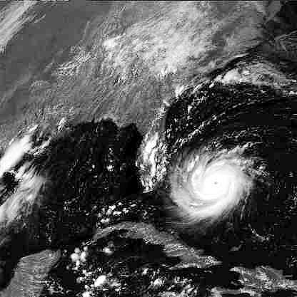
August 23rd 1992 - one of the most devastating hurricanes of recent times - about to strike the coast of Florida
|
Designated 2000 Atlantic Storm names | |
|
Alberto Beryl Chris Debby Ernesto Florence Gordon Helene Isaac Joyce Keith |
Leslie Michael Nadine Oscar Patty Rafael Sandy Tony Valerie William |
|
| Names are used in sequence with a new set being chosen each year. Click link for worldwide storm names for 2000 - 2005. Names in red had already been used by October 2000. | ||
| Hurricane Andrew August 23rd 1992 - one of the most devastating hurricanes of recent times - about to strike the coast of Florida |
||
Hurricane!Hurricanes are intense tropical cyclones, capable of delivering winds of extreme velocity and causing massive damage to a large area. The name hurricane is used specifically for tropical cyclones in the Atlantic Ocean, but similar intense depressions affect other areas of the topics as well. Typhoons affect the China Sea and the coasts of Japan, Philippines and China, willy-willies start in the south western Pacific and track towards Queensland and Papua New Guinea, Cyclones in the Indian Ocean can affect the Bay of Bengal (October - November) or swing south to Madagascar and the eastern coast of Africa from December to March. Atlantic Ocean tropical cyclones (hurricanes) typically form from August to late October, although they can begin as early as June, and are the result of the northward motion of the inter tropical convergence zone (ITCZ) as a result of the seasonal migration of the overhead sun. Hurricanes will only form when a mix of conditions reach the right values:
The ITCZ creates the conditions for air masses to converge at low levels. If this happens over a large area of warm water, where temperature, pressure and humidity are similar over large distances and anticyclonic conditions occur in the upper atmosphere, then intense low pressure and strong winds can develop close to the surface. The rotational motion of the earth means that this atmospheric disturbance tracks westwards, being flung towards the pole as it goes. In the northern hemisphere, hurricances migrate in a west north westerly direction, turning more northwesterly and even north as they go. Heat energy must be available to maintain the rising air. As the warm moist air rises from the surface, condensation occurs releasing massive amounts of latent heat energy. This drives the rotational winds, increasing speeds to the high velocities associated with true hurricanes (120 -160mph). The condensation creates the distinctive rotating clouds which show so well on satellite images and provide exceptionally high rainfall. It has been estimated that the energy released by a hurricane in a single day would be enough to power the United States for six months. The distinctive 'eye' of the hurricane only develops when the hurricane reaches maturity - at this stage the wall clouds surrounding the eye deliver immense rainfall with very high velocity winds swirling around the eye. As the eye itself passes over an observer, the wind will drop, temperatures will rise rapidly and clear skies will be seen. As the eye passes, the high velocity winds will return - but blowing from the opposite direction to before. Once the hurricane moves over land, or over colder water, it loses its source of latent heat energy and rapidly decays. Atlantic hurricanes track across the Caribbean islands, towards the USA, crossing Florida and into the Gulf of Mexico or swinging north to the coast of Carolina. As the hurricane makes landfall it raidly loses energy and wind speeds drop - the hurricane is downgraded to a tropical storm and then to a tropical depression. Hurricane hunt Hurricanes can be tracked using satellite imagery and ground level observations. Early development can be seen from satellite - there are few remote observations stations in the equatorial Atlantic! Check the hurricane watch page for links to satellite images and remote buoy observations for Atlantic tropical cyclones. |
Hurricane Scale
| Hurricane intensities are now graded according to observations of the conditions within the storm. | ||||
| Category | Pressure mb | Maximum Wind speed (mph) | Storm surge(ft) | Damage prediction |
| Depression | less than 39 | |||
| Storm | 39 - 73 | |||
| Hurricane 1 | above 980 | 74 - 95 | 4 - 5 | Minimal |
| Hurricane 2 | 965 - 980 | 96 - 110 | 6 - 8 | Moderate |
| Hurricane 3 | 945 - 965 | 111 - 130 | 9 - 12 | Extensive |
| Hurricane 4 | 920 -945 | 131 - 155< 39 | 13 - 18 | Extreme |
| Hurricane 5 | below 920 | more than 155 | more than18 | Catastrophic |
Hurricane, Typhoon and Cyclone Links
|
Page update: October 2000
