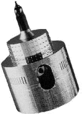
Meteosat
the WEFAX signal
WEFAX was introduced with the first Meteosat in 1977. WEFAX uses a 2.4 kHz carrier signal modulated with a 1.6 kHz video signal. The signal includes frame start and stop tones and horizontal synchronisation bursts for each raster line. The section below shows one raster line with a horizontal sync burst at each end.

Click on one of the icons below to hear the sound of the satellite tranmsission
The composite audio signal is frequency modulated (FM) onto 1691.0 MHz (Channel A1) and 1694.5 MHz (Channel A2) carriers. These are the signals received by typical secondary data stations in schools and colleges. Each line of an 800 line image takes 250ms to transmit with each complete picture taking about 3 and a half minutes. Meteosat operates a dissemination schedule, transmitting images at regular intervals. Not all of the four minute slots are used for image transmission. Some are used for digitally encrypted data, for relays of other satellite images (GOES/GMS etc).
The original Meteosat images are made up of pixels with a value between 0 and 255. These original raw values are preserved in the high resolution primary data transmissions. However, high resolution images rarely have pixels that span the entire range from 0 to 255. WEFAX images are modified using software at the Darmstadt central processing site to enhance the contrast by extending the range of pixel values used. This modification makes the secondary images much more useful to direct eye interpretation but does mean that all the original quantitative information is lost. No realistic image processing or measurements can be made from secondary WEFAX images.
A complete WEFAX format image contains:
- a start signal - 3 seconds
- a phasing signal - 5 seconds
- a digital header - 2 lines - 0.5 seconds
- image data - 800 lines - 200 seconds at 4 lines per second
- a stop signal - 5 seconds
- Satellite name (METn)
Spectral band (VIS, IR or WV)
Date (YY) year, (MM) month, (DD) day
Time (HHmm) hour and minute of the end of image acquisition
Sector (format name)
A stop signal of 450Hz for 5 seconds denotes the end of the WEFAX transmission.
Most of the WEFAX transmitted images are originated from Meteosat itself. Most of these images are transmitted on Channel A1. In addition, images from GOES-E and GMS are retransitted on Channel A2 along with whole Earth disk views from Meteosat (CTOT, DTOT and ETOT formats). Administration messages (ADMIN) and Cloud Top Height analyses (CTH) are also broadcast. CTH images depict the altitude of the highest cloud with values being indicated by grey levels. Black means no cloud above 3000m and white means cloud tops above 12000m.
Other Meteosat information
Acknowledgements:
WEFAX information:
ESA/EUMETSAT
Ross Reynolds, Dept. of Meteorology, University of Reading
Steve Marchant, Nottingham University
St. Vincent College, Gosport
Return to Meteosat information index
Page update: January 12th 1999
This version: © St. Vincent College

